Water hidden beneath Arctic glaciers is moving far more than scientists realized. Now there is a map to prove it.
Researchers have identified 37 active subglacial lakes across the Canadian Arctic, including 33 bodies of water that had not been documented before. The lakes sit beneath or partly beneath glaciers. Furthermore, some of them drain or refill so quickly that the ice above them can rise or fall by more than 100 meters in less than a year.
The work offers the first decadal inventory of active subglacial lakes in the region. It also adds a new layer to the picture of Arctic ice loss in one of the world’s fastest-changing glacier zones.
“Now we can further characterize the way the Arctic environment is changing, which can be an indication of climate change impacts on the region,” said Dr. Wesley Van Wychen, a professor in the Faculty of Environment at the University of Waterloo. “Changes in water storage are important in terms of understanding how the speed of glaciers may change. By measuring the draining and filling of these lakes and determining how quickly this process could happen is another way that we can characterize the impacts of climate change on the Arctic environment.”
The Canadian Arctic holds about 14 percent of Earth’s glaciers and ice caps by area. From 2000 to 2023, the region lost glacier mass at a rate of 53.6 gigatonnes per year. This rate is second only to Alaska among glacier regions outside the great ice sheets.
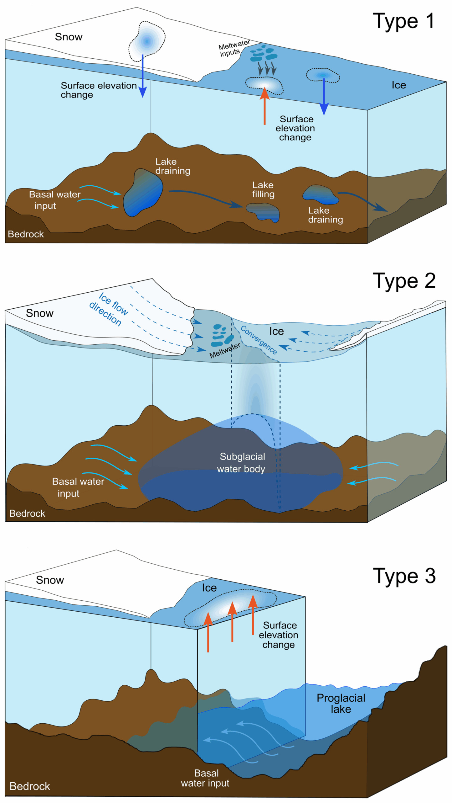
Subglacial lakes are pools of water trapped beneath glaciers. When they fill or drain, the ice surface above them shifts because the water below is either supporting the ice or slipping away. Those vertical changes can be tracked from space.
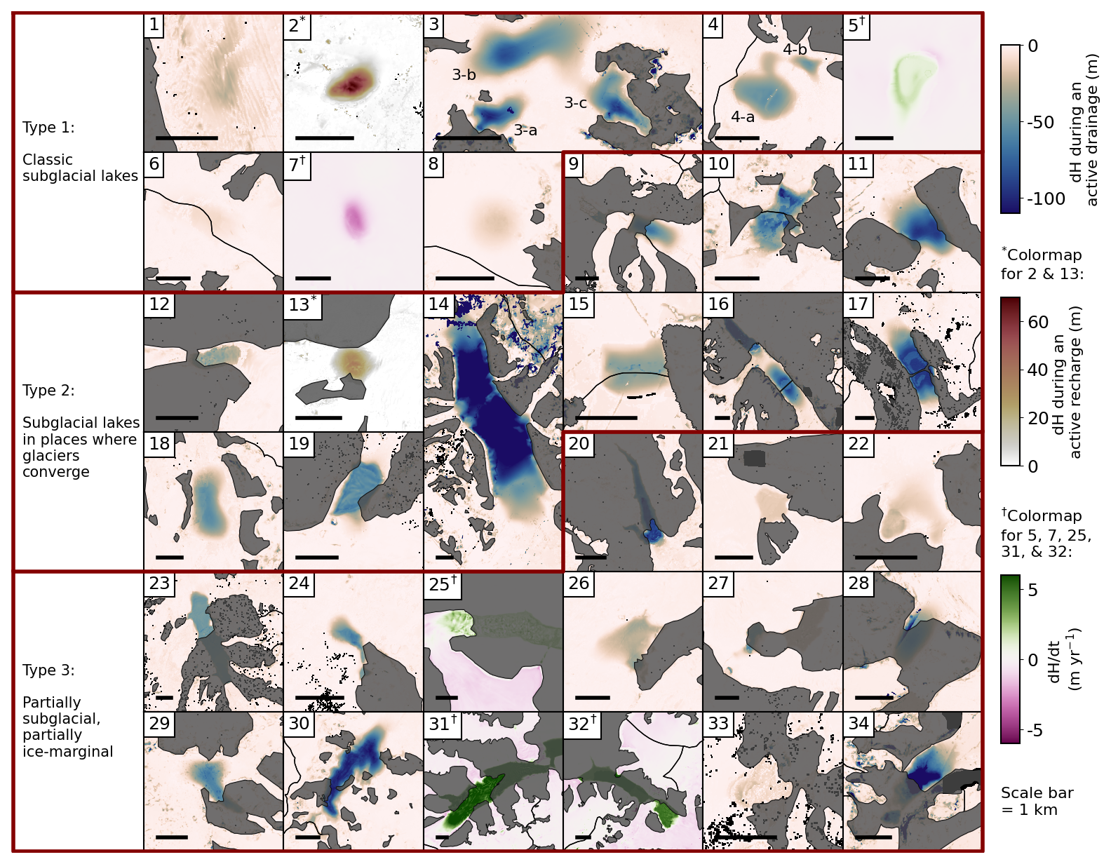
Using ArcticDEM satellite data from 2011 to 2021, the research team built a method to follow those changes in much finer detail than older approaches allowed. Instead of relying on a pair of elevation snapshots, the researchers used repeated measurements over time. As a result, they could reconstruct drainage and recharge events.
That helped them pick out 37 active lakes spread across the Canadian Arctic, from Baffin Island to northern Ellesmere Island. Thirty-two showed at least one abrupt event, defined as more than 10 meters of ice-surface change within a year. Five others changed more slowly over the decade but still appeared active.
One lake, known as Lake 14 in the Manson Icefield, stood apart. It covered 48.5 square kilometers and drained 4.46 cubic kilometers of water between late 2020 and early 2021. During that event, the glacier surface above it dropped by as much as 148 meters.
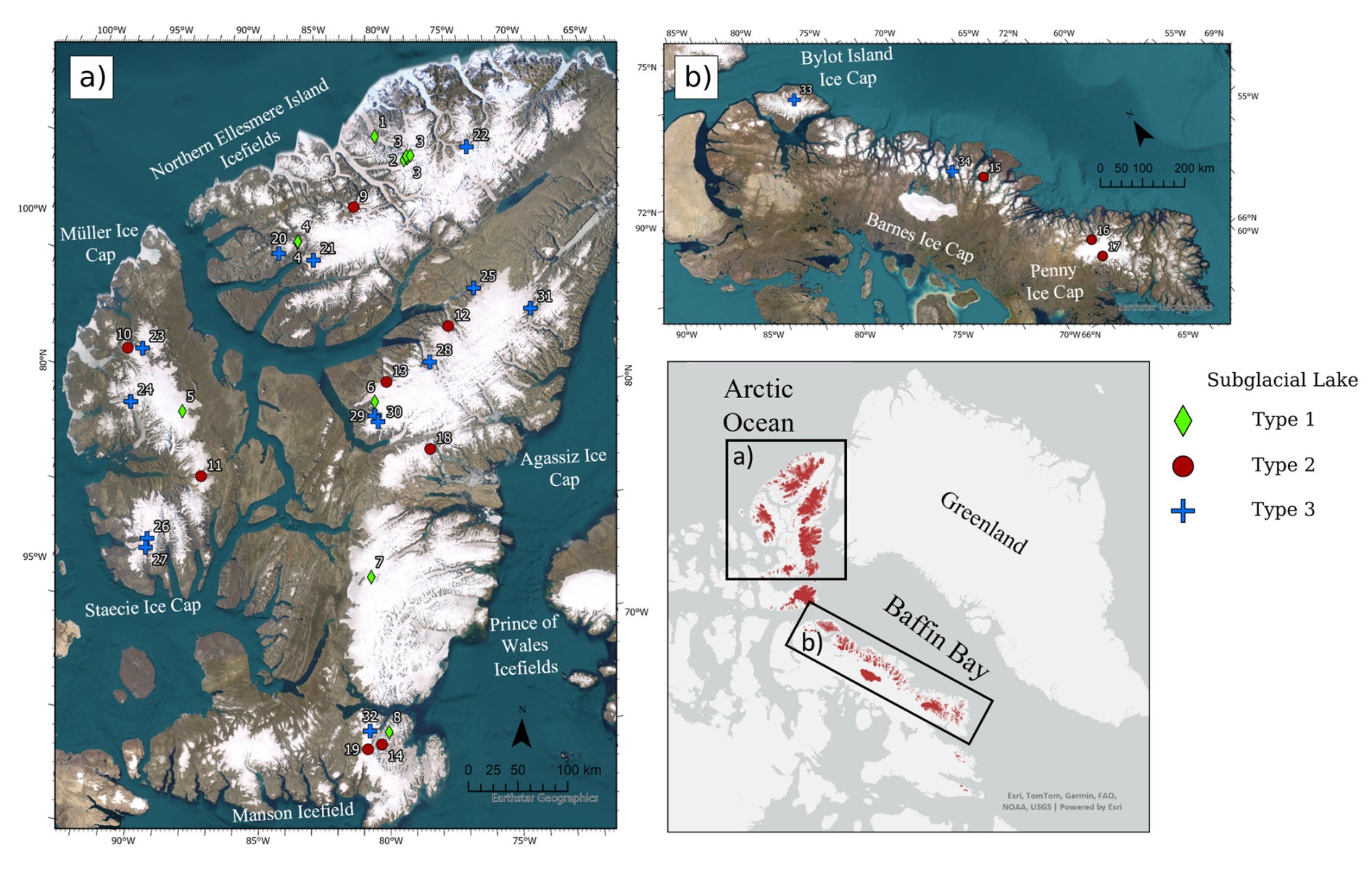
The study also proposed a new three-part classification system. Eleven lakes were “classic” subglacial lakes, sealed beneath a single glacier. Another eleven were found where two glacier termini converge in valley terrain, a newly defined category the researchers call terminal subglacial lakes. The remaining fifteen were partial subglacial lakes, where part of the water body connects to open water at the glacier margin.
That distinction matters because water beneath ice can change how a glacier moves.
“What’s important about creating this kind of classification system is that the glacier flow speed will be impacted differently depending on what type of lake it is,” said Dr. Whyjay Zheng, first author of the paper and a professor at National Central University in Taiwan. “Whenever you have a body of water underneath a glacier, that water can act as lubrication between the glacier and its bed, allowing the glacier to move faster.”
Most of the lakes followed the same broad rhythm: slow recharge over several years, then rapid drainage within months. In a few cases, nearby lakes appeared linked, with drainage happening in sync.
Yet the study also found something unexpected. Despite earlier research suggesting that draining subglacial lakes can speed glacier flow, the team did not see a clear effect on ice velocity in most of the Canadian Arctic lakes they tracked. Only one lake showed a possible speedup during drainage.
Even without a strong velocity signal, the lakes still seem tied to the Arctic’s broader ice losses. The researchers found a significant correlation between the yearly number of short-term lake events and regional glacier mass change between 2012 and 2021. That suggests heavier melt years may help trigger more lake activity by changing water supply and subglacial drainage pathways.
The study comes with important limits. It cannot detect stable subglacial lakes that do not deform the surface above them. ArcticDEM coverage is uneven across seasons, especially in winter darkness, so the exact timing of many events remains uncertain. The method may also underestimate how much water moved, because ice can flow into a depression after drainage.
Researchers now want to test how stable these lakes really are, where the water goes during drainage, and whether those events shape glacier behavior in ways current models miss.
This map gives scientists a better way to track hidden water beneath Arctic glaciers. That matters because that water can affect how ice is lost and how glacier mass balance is measured.
It also suggests that some satellite estimates may blur together changes in ice and changes in stored liquid water.
As warming continues in the Canadian Arctic, separating those two processes could become more important for understanding glacier retreat. Moreover, it could improve sea-level projections.
Research findings are available online in the journal EGUsphere.
The original story “First-ever map documents 33 glacial lakes hidden under the Canadian Arctic” is published in The Brighter Side of News.
Like these kind of feel good stories? Get The Brighter Side of News’ newsletter.
The post First-ever map documents 33 glacial lakes hidden under the Canadian Arctic appeared first on The Brighter Side of News.