Latitude shapes climate in a basic but powerful way. It controls the angle of sunlight, which helps decide whether a place tends toward ice, desert, rainforest, or something in between. That simple fact becomes a problem when you are trying to understand a world that no longer exists.
A rock found in the Netherlands today may not have formed anywhere near the Netherlands.
That is the challenge behind a new online tool created by an international team led by Utrecht University Earth scientist Douwe van Hinsbergen. The site, Paleolatitude.org, lets users click on nearly any point on Earth and estimate what latitude that place occupied millions of years ago, back to about 320 million years ago, when the supercontinent Pangea dominated the planet. The work appears in PLOS One.
The tool rests on what the team calls the Utrecht Paleogeography Model, a reconstruction of ancient plate motions that aims to place rocks, fossils, and landmasses more precisely in their former positions. For scientists who study climate, oceans, and the history of life, that matters because the past cannot be read from geography alone. Continents drift, ocean basins open and close, mountain belts crumple, and pieces of crust vanish into Earth’s mantle.
“Next time you go on a trip, take a look at Paleolatitude.org to see the journey your destination has taken itself.”
For paleoclimate researchers, latitude is not a side detail. It can change the whole meaning of a fossil, a sediment layer, or a chemical signal locked inside ancient rock.
Utrecht scientists offer a striking example from Winterswijk in the eastern Netherlands, where they study 245 million-year-old plants and animals that lived in conditions resembling today’s Persian Gulf, with desert heat and a tropical sea. That raises an obvious question. Was the whole planet dramatically hotter at the time, or was that part of Europe once much closer to the latitude of Arabia? Earlier work by the Utrecht group had already pointed to the second explanation.
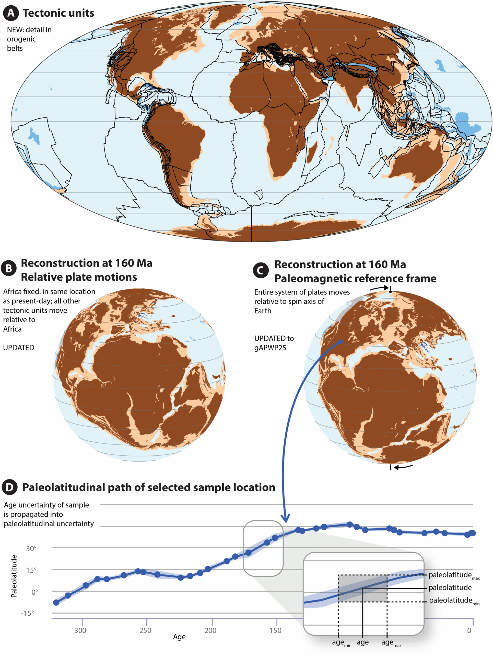
The new version of the model tries to answer that kind of question with more confidence than earlier tools allowed. Older reconstructions could capture broad continental movements, but they often struggled with smaller tectonic plates, highly deformed mountain belts, and fragments of crust that no longer exist as intact landmasses. This upgrade folds many of those missing pieces into a single global system.
That includes so-called lost continents and microcontinents such as Greater Adria, Argoland, and the Tethys Himalayas, whose remains are now preserved as folded rocks in places including the Mediterranean region, the Himalayas, and Indonesia.
Van Hinsbergen put the advance this way: “This means that, for the first time, a truly global model is now available that allows you to link those rocks to their original plates, which have since disappeared into Earth’s mantle. The global journey of those rocks can now also be traced.”
Building a reconstruction like this takes two main steps.
First, geoscientists work out how tectonic plates moved relative to each other. In deformed mountain belts, that can mean effectively unfolding rock packages that were bent, stacked, shortened, or shifted by long episodes of collision and subduction. The team says the new model draws on detailed regional reconstructions from areas including the Mediterranean, Iran, the Himalaya and Tibet, Southeast Asia, the Caribbean, and parts of China and Indochina.
Then comes the second step, placing that whole reconstruction at the right latitude on the ancient globe.
“But then that entire reconstruction needs to be placed at the correct latitude. That is important for climate research, for example,” said co-author Bram Vaes of CEREGE in Aix-en-Provence, France.
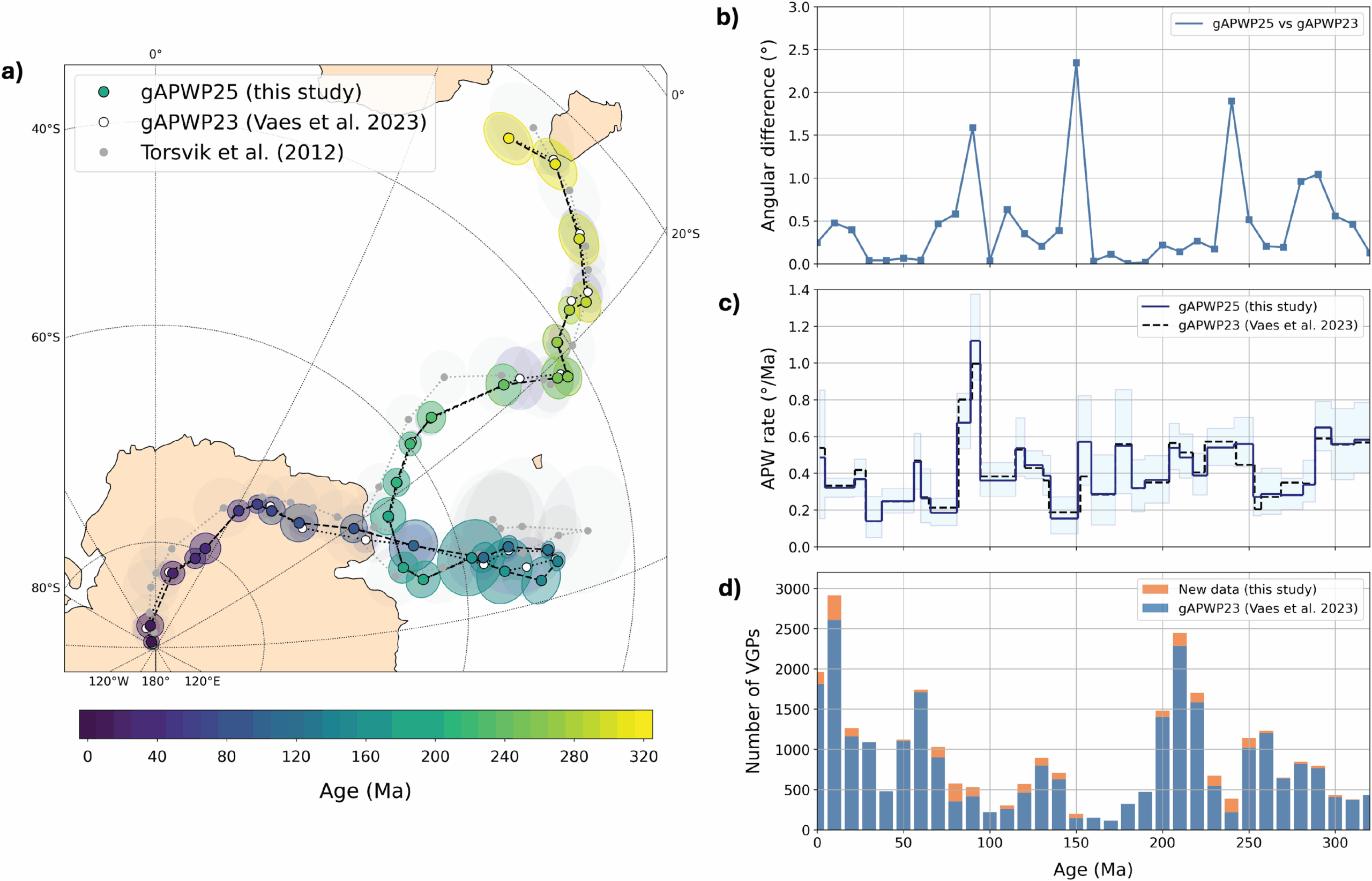
To do that, scientists rely on paleomagnetism, the magnetic information preserved in rocks. Because Earth’s magnetic field meets the planet’s surface at different angles depending on latitude, magnetic minerals can preserve a record of where a rock formed. Combined with dating methods, that gives researchers a way to estimate the latitude of ancient rocks and, by extension, the movement of the plates carrying them through time.
The authors say the updated version of their paleomagnetic reference frame, called gAPWP25, adds 32 entries to the earlier database, about a 10 percent increase. Compared with the previous version, the differences are generally small, though the new path reduces uncertainty somewhat by drawing on more data.
One of the larger changes in Paleolatitude 3.0 is that it goes far beyond the rigid interiors of the biggest tectonic plates.
That matters because many important fossils and rock records come from mountain belts, not quiet continental interiors. Orogenic belts, the vast zones where crust gets compressed, stacked, stretched, or accreted, preserve rich records of oceans that closed and continental fragments that collided. Yet they are also some of the hardest places to reconstruct cleanly.
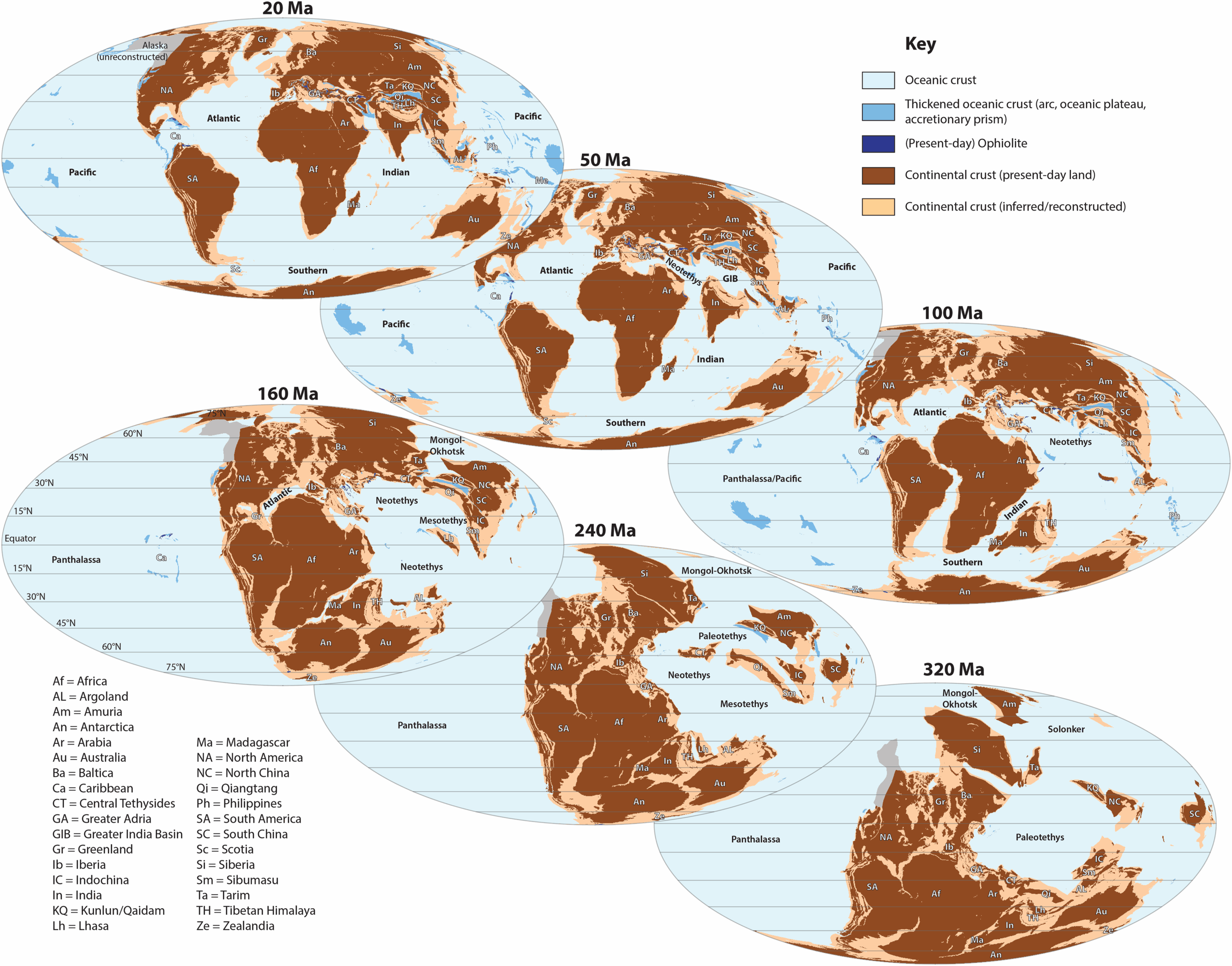
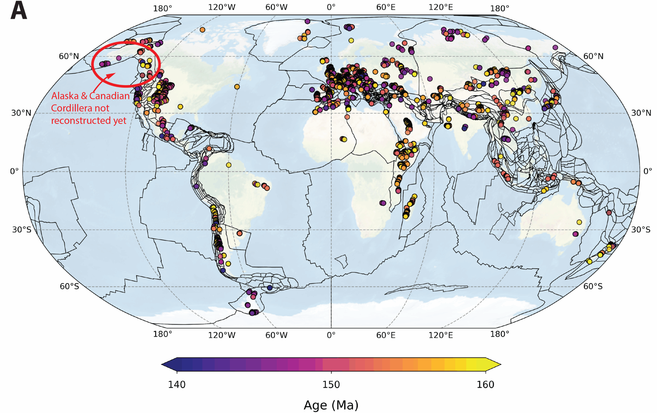
The Utrecht model divides those regions into many rigid polygons that represent crustal blocks with shared origins. In some intensely deformed places, the polygons are only tens of kilometers across. That lets the system estimate paleolatitude for rocks in geologically messy regions such as the Alps, the Zagros, the Himalaya, Japan, New Zealand, and parts of California and Alaska, although not every disputed or poorly resolved region is included yet.
The model also stretches back through the major rearrangements of the last 320 million years, from late Carboniferous Pangea through the breakup of the supercontinent, the opening of the Atlantic and Indian oceans, and the repeated opening and closing of Tethyan basins between Gondwana, Eurasia, and the China blocks.
Some of those histories are still debated. The authors say so plainly. Their reconstruction makes choices where the field remains unsettled, and some regions, such as parts of the Canadian Cordillera, Alaska, and pre-late Cretaceous northeast Siberia, are not yet included because no available reconstruction met their standards.
The public-facing website allows users to click on a map and generate a paleolatitude curve for a location back through time. Up to ten curves can be shown at once. Users can also enter coordinates manually, choose ages or age ranges, and download graph outputs or Excel files.
There is also a batch option for bulk calculations using Excel or CSV files. The paper says there is no maximum number of entries, though very large files with tens of thousands of records may take hours to process.
For researchers, that bulk feature may be one of the most important additions. It makes it easier to recalculate paleolatitudes for large fossil datasets while also estimating uncertainty for each point.
That uncertainty is a central part of the pitch. Earlier paleogeographic tools often gave users a paleolatitude estimate without a clear error range. Paleolatitude.org 3.0 combines uncertainty in the paleomagnetic reference frame with uncertainty in fossil or rock age. That opens the door to more careful comparisons across time and space.
The implications go beyond tectonics.
Mountain belts preserve many fossils, and better paleolatitude estimates could help paleontologists ask more precise questions about how biodiversity shifted with climate. Emilia Jarochowska, a Utrecht paleontologist and co-author, says the improved application may help scientists test long-standing ideas about mass extinctions and recovery.
“This allows us, for example, to show what happened to global biodiversity during and after mass extinctions in the past, for instance due to Earth rapidly warming or cooling,” she said.
“Which latitudes became uninhabitable first, and which became refuges? Which species migrated, which adapted, and which went extinct?”
Jarochowska argues that stronger paleogeographic control changes the problem itself. “With the new model, we have much greater certainty, and our understanding of biodiversity is shifting from one-dimensional, that is, solely over time, to three-dimensional, encompassing space as well. This enables us to draw important lessons for the resilience of biodiversity in the present.”
The paper illustrates that idea using fossil datasets, including about 34,000 Upper Jurassic marine fossils used to examine the latitudinal diversity gradient, the long-observed pattern in which species richness tends to be higher at lower latitudes. The authors say the tool can now help propagate age and location uncertainty into such calculations instead of treating each fossil occurrence as a single fixed point.
The authors do not present the reconstruction as final.
They note that simplifying geologically complex mountain belts into a global 2D model inevitably loses detail. Small georeferencing errors may place a coordinate in the wrong tectonic polygon, which could produce an incorrect paleolatitude. In most cases, they write, such errors are likely limited to a few degrees, but they still matter.
Some passive margin reconstructions remain incomplete, and pre-breakup extension on those margins may shift estimates by up to about 2 degrees if rifting had a north-south component. Not every contested tectonic interpretation is resolved, and some regions remain absent pending better reconstructions. In one example involving a Late Jurassic marine fossil dataset, the team discarded about 1,000 fossils from Alaska and the Canadian Cordillera because those areas are not yet included in the model, likely causing some underestimation at low to mid-northern latitudes.
Even so, the new system appears to mark a significant move toward a more detailed and more transparent global framework.
The team says the model will eventually be extended back to roughly 550 million years ago, reaching the Cambrian explosion of complex life.
For Earth scientists, this tool could make ancient climate and biodiversity studies less guesswork-heavy by improving where rocks and fossils are placed on the globe, and by attaching uncertainty to those estimates. That is especially useful when researchers are comparing life near the tropics, near polar circles, or across periods of rapid warming and cooling.
For paleontologists and geologists working in complicated mountain belts, the upgrade may also help connect scattered rock units to the vanished plates they once belonged to.
And for the wider public, it offers something rare in tectonics, a direct way to see that the ground beneath modern cities, coastlines, and holiday destinations has traveled a very long way.
Research findings are available online in the journal PLOS One.
The original story “New tool tracks lost continents and moving plates over the last 320 million years” is published in The Brighter Side of News.
Like these kind of feel good stories? Get The Brighter Side of News’ newsletter.
The post New tool tracks lost continents and moving plates over the last 320 million years appeared first on The Brighter Side of News.