The Rujm el-Hiri, located on a large basalt plateau in the Golan Heights, is a large ring of stones that has been an isolated archaeological site for decades. Scholars debated its purpose endlessly, whether it was a burial site, a ceremonial gathering place, an astronomical observatory, or something else entirely.
What nobody seriously entertained was that it might simply be the largest and best-preserved example of a much broader regional tradition. Turns out, that is exactly what it is.
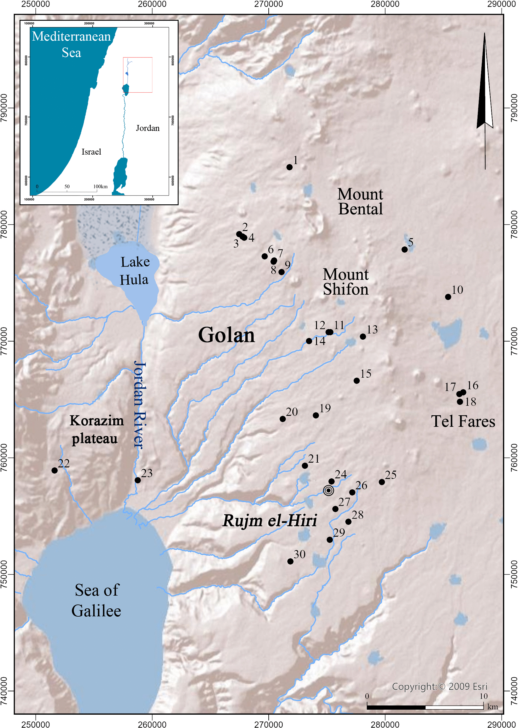
Using new research, Dr. Michal Birkenfeld and colleagues from Ben-Gurion University of the Negev conducted an analysis indicating that more than 28 other stone circles have been found within approximately 25 km of Rujm el-Hiri. This new evidence shows that archaeologists are shifting their view of the site, from an isolated structure to part of a larger tradition of stone circles that had previously gone unnoticed.
The circles are not new; they have always been part of the landscape. They just have not been recognizable as such.
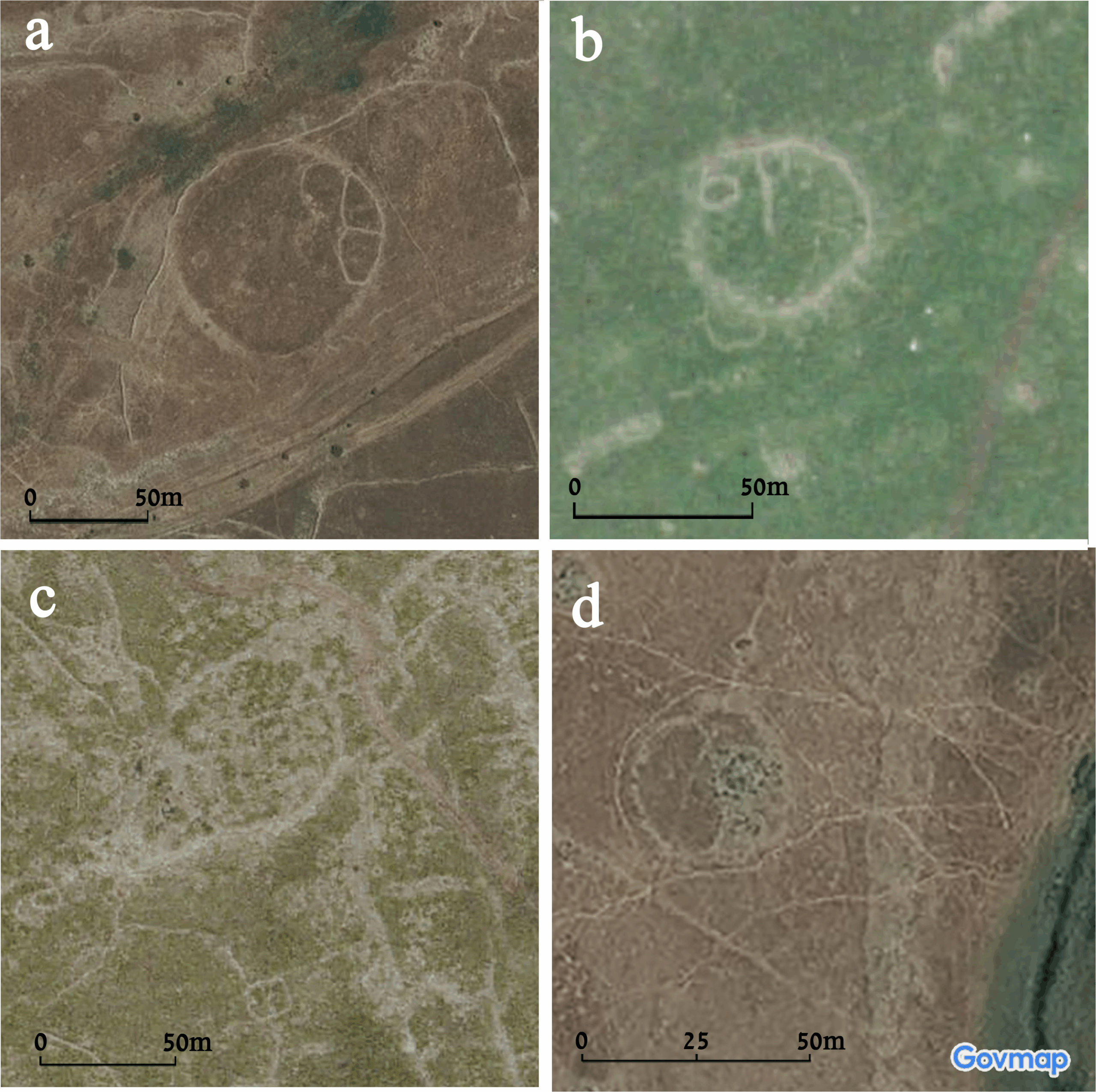
Over the past twenty years, researchers have used high-resolution satellite imagery in conjunction with geophysical modeling and spatial analysis to develop their findings. By layering images taken under different seasons and lighting conditions, and comparing them with environmental information, the team was able to discern subtle shapes that reveal the underlying structure of various stone circles.
Differences in vegetation and the presence of shadows created by the structures enabled researchers to map walls and circular enclosures that were previously missed in earlier surveys.
Dr. Birkenfeld states, “By combining these two disciplines, we have produced the most magnificent example of a regional phenomenon known as Rujm el-Hiri.” The newly found stone circles form a repeating pattern.
Once plotted as a group, the newly discovered stone circles appear less like a collection of curiosities. Instead, they form a cohesive system.
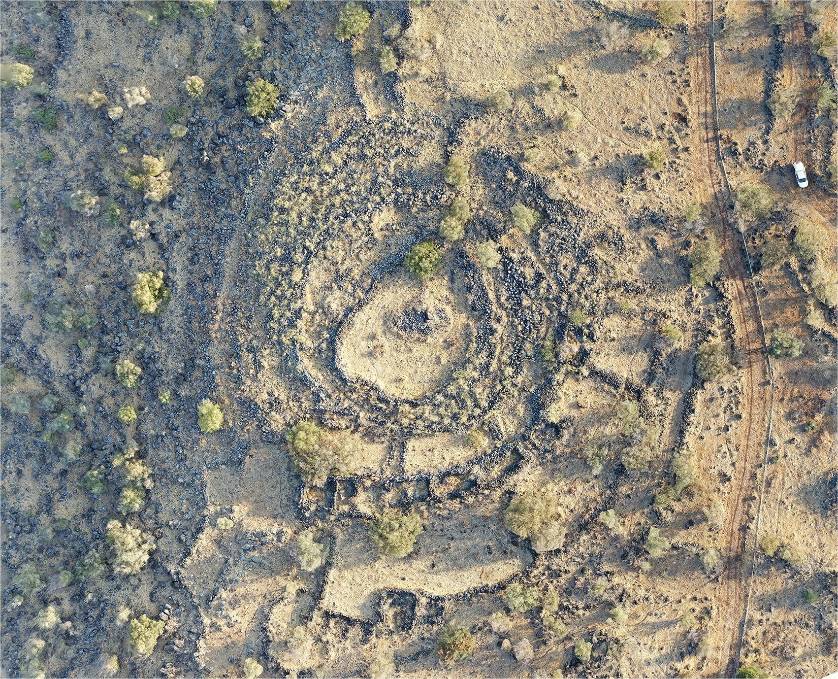
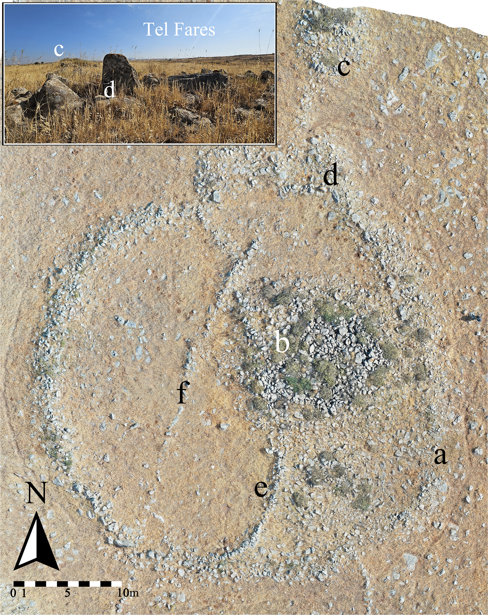
The stone circles, often measuring from approximately 50 meters to 250 meters in diameter, generally consist of concentric rings of basalt stones collected locally. Some stone circles feature concentric outer walls made with local basalt stones and include smaller attached chambers or radial divisions inside the circle. Most, however, are defined by a single circular peripheral wall of basalt stone.
Inside some circles, there are structures that were either built after the stones were buried or constructed directly into the burial stones after they were placed in the circle. In some cases, few internal structures appear. In other instances, the interior features were cut through by later constructed stone walls, providing evidence of reuse of both the stone and the construction method.
The majority of stone circles appear to be clustered together. Some circles are placed only a few meters apart, while others, although not directly connected, form more distant aligned points across the landscape.
Although the stone circles differ, they share three major characteristics: thick circular walls constructed of similar basalt stone, similar construction methods, and comparable design or layout.
Reconsidering the question of the historical context of the Rujm el-Hiri stone circle, the site has intrigued researchers for many years.
Rujm el-Hiri, as previously mentioned, has a grave marker (cairn) at its center and is surrounded by many concentric walls, with an overall diameter of at least 150 meters. The central cairn measures about 40 meters in diameter. Although many researchers have considered the site a burial location, others have speculated that it was used for ceremonial or religious gatherings, military purposes, or astronomical observations.
However, these theories do not provide a definitive answer to the purpose of the site.
A major complication in developing further arguments has been its apparent singularity. The Rujm el-Hiri site did not have similar nearby sites, making it difficult to place it within a broader cultural or functional context. That gap is now closing.
The presence of numerous similar circles suggests that the monument was part of a larger system rather than an isolated construction. This shift in perspective changes prior interpretations of the site.
The inability to accurately align the site with celestial events is also reconsidered. New data show that the site has experienced gradual tectonic rotation over thousands of years, reducing the reliability of astronomical alignments based on current orientation.
The circles were not placed randomly. Their locations appear linked to seasonal water sources, with many positioned near streams or fertile landforms shaped by the volcanic geology of the region. The plateau includes areas historically used as grasslands, forests, and agricultural land.
This pattern suggests that communities used the land differently than today. The circles may represent gathering points where multiple communities marked territorial claims and accessed seasonal resources.
Prof. Lev Appelbaum, a co-author from Tel Aviv University, has focused on identifying undiscovered archaeological sites in the region using remote sensing methods. This approach supports the idea that the circles were part of a broader network that included enclosing walls and other stone-built features.
The shift in archaeological interpretation is a key outcome of this discovery.
There are still many unanswered questions. Much of the newly identified data remains unexcavated. Dates for many circles cannot yet be determined, and some have been modified over time, complicating efforts to understand their original purpose.
However, when viewed on a larger scale, interpretation has expanded. What once appeared to be a single, isolated structure is now part of a broader pattern of land use shaped by human activity over time.
This broader pattern indicates that communities across the landscape interacted through organized movement. They were aware of one another and may have coordinated how the land was used.
This method of analyzing archaeological data in relation to physical structures represents an advancement over traditional approaches used in the region.
The analysis of these circles helps archaeologists develop new theories and methods for studying large monument systems, especially when sites are initially identified in isolation. It also improves the ability to identify similar structures in the future.
Finally, the use of remote sensing techniques opens the possibility of discovering archaeological sites that are not physically accessible.
For the Golan Heights, this discovery provides greater clarity. Rujm el-Hiri is no longer just a mystery, but a reference point within a larger, integrated system.
Research findings are available online in the journal PLOS One.
The original story “Satellites solved a 50-year mystery about Israel’s ‘Stonehenge’” is published in The Brighter Side of News.
Like these kind of feel good stories? Get The Brighter Side of News’ newsletter.
The post Satellites solved a 50-year mystery about Israel’s ‘Stonehenge’ appeared first on The Brighter Side of News.


Leave a comment
You must be logged in to post a comment.